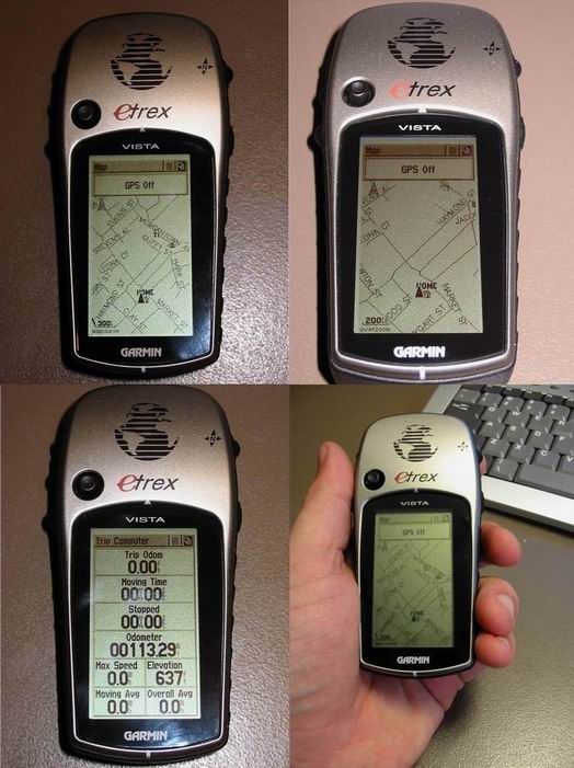
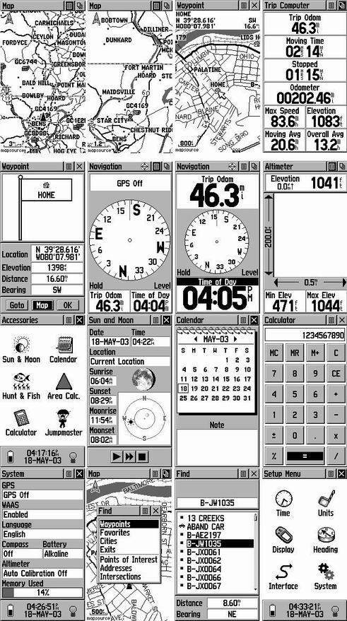
| First Impressions: If you haven’t had the chance to see one of there in person, and hold it in your hand, the unit is smaller than it looks on the net. It fits nicely in your hand, and can be operated with just one hand. The Vista is the highest, most advanced version of the etrex. They are: Yellow, Summit, Venture, Legend, and Vista. Only the Legend and Vista offer downloadable detailed maps.
Fit & Finish: The Vista is very well made. It feels very sturdy, and has no loose, rattles to it. The sides are covered in a soft black rubber, that makes the unit very easy to hold, even when wet. (yes, its water proof to 3 feet for 30 minutes) The screen is almost completely flush with the body, there is not really a need to recess the screen, due to its size, it would get hit anyway. The buttons are firm, and should not be accidentally pressed. The battery compartment tightens down nicely by turning the metal latch on the back a quarter turn. Screen: The Vista has the highest resolution screen of all the Garmin products. This helps compensate for its small size. The screen is a 4 gray scale LCD backlit display. The contrast is very good, and can even be read in most sunny situations. The blue/green backlighting is very bright, and covers the entire screen evenly. The Vista has the smallest screen of almost all the GPS units out there, but that is due to the units very small size. The resolution does make up for most of that though. Interface: The majority of the navigation and functions are controlled by the “click stick”. Its the little black joystick to the left of the etrex logo. You control it with your thumb. It takes a little getting used to at first, you have to be gentle so that you don’t accidentally click up when you mean right, etc. You can press up, down, left, or right. Pressing the “click stick” serves as and enter button. After you get used to this it is a pretty fast way to go through the Vistas features and options. Mapping: The Vista comes with a basemap of the US of Europe, depending on your location. This map is a good start, but it only displays the major interstates and highways. No residential streets or even medium size highways are included. Garmin offers additional mapping software that can be uploaded to the Vista. These include, Roads and Recreation, Metroguide, and Topo Map. For the most part, R&R and Metroguide are the same. MetroGuide offers address lookup, and more advanced search features. R&R is based on less updated TIGER maps. Metroguide is now based on NavTech, which supplies the same maps to the dedicated car navigation systems. These are far more accurate and complete than the TIGER maps. The newest version of Metroguide allows you to autoroute a trip on your PC, and then dump it to the Vista. The unit comes with a serial cable to use for uploading maps and waypoints from your PC. The cable also allows you to connect the Vista to a laptop and display your position on the laptop in real time ! Customizing: Just about every single page on the Vista is customizable. For example: the Trip Page has 8 data fields it can display at once. Every one of these can be made to display what ever you want. Simply use the “click stick” to highlight the box you want to change, and hit enter. A list of options will be displayed. Speed, Max Speed, Trip Odometer, Time, ETA, Elevation, Bearing, Distance to Destination, ETC. I’d list them all, but there are just too many. Just trust me, if you want to know it, it will tell you. Accuracy: I will not go into great detail over the accuracy of this unit. There are just too many variables to this. For the most part, this unit is as accurate as any other unit with a patch antenna. Some units have a Quad Helix antenna, which is better at picking up satellite signals in difficult situations. This unit is WAAS enabled. Which means it is capable of receiving signals from the two WAAS satellites that are currently in orbit. This allows the unit to have an accuracy of as close as 9 feet! In typical use, the unit will get about 20 feet accuracy. Power: The etrex units all run off 2-AA batteries. You can typically get about 8 hours of use out of a set of batteries. The more use go through the pages, and use the backlight, the less time they will last. Pros: Very small size, great for hiking. Tons of features, and customizable screens. Excellent customer service. Software Updates available Free at www.Garmin.com. Water Proof to 3 feet. Much better software (in my opinion) than its competitors. Easy one hand operation. Cons: Screen can seem small at times. No external antenna hookup. Will not float. Conclusion: This is a great all around unit. In my opinion, it is the best unit for hiking, camping, hunting, or any outdoor activity. Due to its small size, and water resistance. I have had no problems what so ever with this unit. i love it more every time I use it. I would not recommend this unit to someone wanting to mainly use it in the car. Its small size and small screen can make it hard to use while driving. |
|
|